Google Launches Street View For Monuments in India: Will Start With 100 Monuments

The Archaeological Survey of India(ASI) has partnered with Google to create a 360 degree imagery of India’s important heritage sites, which will include Taj Mahal, Khajuraho and Ajanta and Ellora caves.
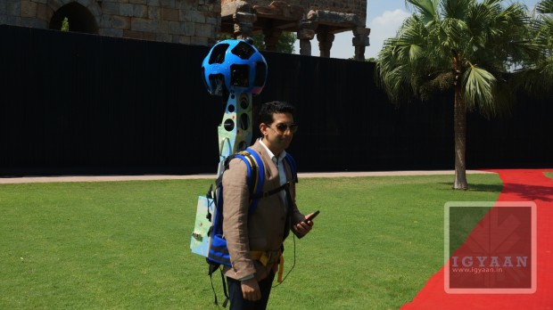
The company claims that the mission is to make information more accessible, as Google hopes to help make more of India’s heritage accessible to people around the world and also to preserve the history for the coming generation. Starting today Google will work with the ASI to bring the street view trekker, a wearable bag like designed device with a camera system on top, check it out in the image below.

Street View Trekker
This trekker is designed to capture images in remote sites or places that are only accessible by foot. Once published, this imagery of the Indian heritage will be available on Google Maps and on World Wonders Site. Part of Google Culture Institute, the Google Worlds Wonders Project is a platform which brings online the major world heritage sites of the modern and ancient worlds. At the launch vice president and managing director of Google India said:
In a country like India, where we have the world’s second largest population and 5,000 years of history, rich and cultural diversity, technology can help us share the Indian experience with the rest of the world – and each other- more effectively than ever before. We’re honored to be working with the ASI to help make these important Indian heritage sites available for the world to experience online.”
The Union Minister of Culture Smt. Chandresh Kumari Katoch said during the launch:
India’s historical and archaeological sites are an important part of the world’s knowledge, and through this partnership with Google we hope to engage more people, both around the world and here in India, in discovering and learning about our country’s rich history.”


